

Bundle Up, Coldest Air of the Season Coming to Minnesota
We've had it pretty easy from Old Man Winter so far this season across Minnesota. We've had a few recent shots of cold, but things are about to get serious.
The coldest air of the season is set to arrive this weekend, with a multi-day stretch of sub-zero temperatures and wind chills.
The coldest periods will be Sunday, Monday, and Tuesday mornings when wind chills will comfortably fall below -25° and will likely make a run towards -40° across portions of central Minnesota.
Actual air temperatures are forecast to remain below zero from Saturday night through Tuesday morning.


During the upcoming blast of bitter cold, frostbite will be possible on exposed skin in less than 30 minutes (and possibly even quicker). Without proper clothing and shelter, individuals could experience hypothermia in the expected weather conditions.
So What Exactly is Wind Chill?
According to the National Weather Service, the wind chill temperature is how cold people and animals feel when outside. Wind chill is based on the rate of heat loss from exposed skin caused by wind and cold.
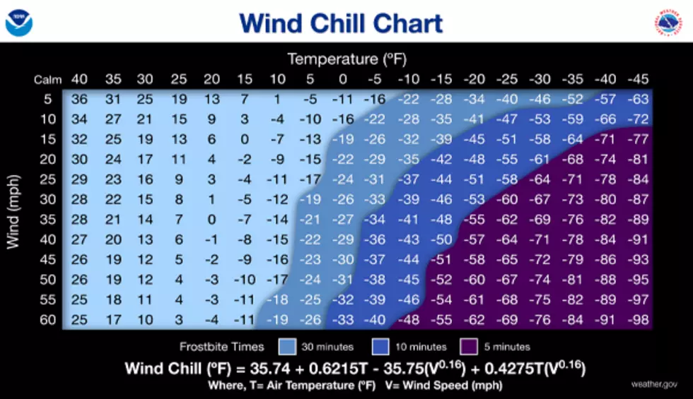
As the wind increases, it draws heat from the body, driving down skin temperature and eventually the internal body temperature. Therefore, the wind makes it FEEL much colder. If the temperature is zero and the wind is blowing at 15 mph, the wind chill is -19. At this wind chill temperature, exposed skin can freeze in 30 minutes.
New Weather Alerts for 2025
Instead of the Wind Chill Advisories and Wind Chill Warnings of the past, this year the National Weather Service will start issuing Cold Weather Advisories, Extreme Cold Watches and Extreme Cold Warnings.
It's likely we'll see some of those alerts come into play during the upcoming arctic blast.
21 Unwritten Rules Every Minnesotan Should Know
Gallery Credit: Minnesota Now
10 Highest-Rated Minnesota State Parks
Gallery Credit: Minnesota Now